
Anyhow, I used the weekend of 15th Dec (see, see, the lazy bum write NOW!) to finally get around to trekking the Pushpagiri. Which a lot of folks know as Kumara Parvata. Over the last 3 years, we'd made atleast 2 other plans that I know of to trek, which for the usual reasons (hey, I was not to blame, OK) fell through.
As always, we suddenly decided that we had to trek Kumara Parvata and as it happened it was a Wednesday. We figured we will ask for permission to camp and asked at the Forest office in Malleshwaram. As it turned out that was entirely superfluous. More on that later. Because we decided late, no tickets were available to Subramanya, where the climb starts. Word of advice, be sure to get a booking in one of those Volvos. We booked our selves on the last seats on the last bus to Hell. The seats kept sliding and the driver was obviously someone who rode a moon buggy, for the crater sized pot holes on the ghats didn't tempt him from stepping off the accelerator. The last part of the ride - post Doingal near Sakleshpur are, to put it mildly, torturous. Be that as it may, we arrived a little worse for the wear at around 7 at Subramanya. For the finicky amongst us, the temple complex has facilities - quite decent I might add.
The route to the climb is to the right of the temple (if you are facing the temple). You will need to walk up a bit and there is a gap between the shops and pretty much follow the road. I'd heard from a lot of people that KP is quite tough and while I will not disagree, it is primarily due to the fact that it is quite long. The first 200 to 300 mts is densely forested and slightly damp so there are chances of leech bites even in winter. Once you come out in the open, it is quite sunny and if you choose the wrong season, it might be quite harsh even. A little after you cross the wooded area, you will chance upon Bhat's house (Bhatre mane). He provides breakfast upto 9.30 I think and start lunch at 12.30. 30 INR for one lunch, didn't ask about breakfast. So the point is if you are going to get here between these times, it would make sense for you to go ahead and not stop. We spent about 2 hours idling about here.
And here is the other reason, why you should keep on going. There is a forest office (house? outpost?) just a couple of minutes up Bhat's house. You'll need to get permission from here to camp. As I mentioned earlier, this permission seems moot. There is a 70 INR charge to trek. You will have to haggle if you want to camp. You'll be first told with a look of great regret that you cannot camp. Even after you clinch the deal there is a baleful look of having done you a great favour. You'll thank your stars for this stroke of luck for about as long as it takes you to spot the other lucky ones ahead or behind you on the mountain
There is an old heritage structure up the face of the mountain called the Mantapa.
 You could camp here, but if you are a large group (anything over 4) it's difficult. There is a water source near by, but not much of a level ground to pitch a tent. We moved further along and almost reached the top before night fell - and it fell fast. To give you an idea, I was the slowest one (which why the title) and climbing out of Bhat's house at around 1.30 in the afternoon took us about 5.30 in the evening to be just short of the top (there is no peak as such here). We stopped liberally to soak in the views and to replenish our selves. Which is a word of advice. Since we pretty much caught the last bus out, we didn't load up on water. Carry enough and more water and lime/moosambi. It was the moosambi pieces that did the trick for us. A quarter of a sweet lime every 45 minutes and you are good to go.
Just short of the top, you will run into another wooded area. This is a typical Shola forest and you can find a place to camp here. There is a water source nearby, and a couple of clearings that you don't need to work too much to pitch your tent. You can also go all the way to the top, because it really is a short climb - unless you are very tired or it's too dark. There are some scary verticals that you need climb when it is nice and bright. Or bright enough to see where you will fall ;).
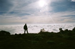
We started our climb and descent around 5 in the AM. Budgeting a half an hour break to admire the show that the sun and clouds had put up for our benefit, we were down the peak and about 15 kms from Somwarpet by 11.30. To get down to Coorg, the descent is in the same direction as you came - for a short while, and then take a right. There are no landmarks, nothing so you will have to spend some time hunting. The only idea that you can have is that the route to Coorg is to the far end towards the south-west. Now here is the kicker. You will find 0, zip, none, nothing to transport you once you get down. So unless you had your own transport - and asked the driver to stay at Somwarpet and come and pick you up near Bidalli you are screwed. Which is exactly what happened to us. Till a bloke took pity on us and piled us along with the fish that he was selling and dropped us off at Shantahalli. Which itself is about 8 kms from Bidalli where you will descend. The village of Bidalli is exactly 5 houses. Don't count on getting anything beyond the rudimentary biscuits. Besides the shop is closed on Sunday. There is a bus at 9 AM from here but that might not run on Sunday either. The only way to get out of hiking another 10 kms from the junction where the road from Bidalli meets the road to Somwarpet is to have someone willing to pick you up at Bidalli. Alternatively you can climb from Coorg and get down at Subramanya. There are more options of transport from here on account of the temple.
While we were done with our climb and descent by 11.30 in the morning, it was 4 in the afternoon before we got any transport and we reached Bangalore around midnight.
For those of you who have a GPS unit, these might help. Subrahmanya 12*40.000' 75*35.600' 123mts, Bhatara mane 12*40.156' 75*39.144' 836mts, Mantapa 12*39.815' 75*40.133' 1204mts, Campsite 12*39.889' 75*40.803 1576mts, Peak 12*39.719' 75*41.201' 1712mts
But it is all worth it. After all it's not every day you get a fitness check up like this.
